About
Visit Us
News and Events
History
Affiliations
Research
Gravity Field
Quantum Pathways Institute
3D Geospatial Laboratory
Radar Applications
McDonald Geodetic Observatory
Satellite Geodesy
Cis-lunar Exploration
Small Satellite Technologies
Urban Climate Studies
Missions
Current Missions
SCOPE
ICESat-2
ABOVE
STV
GRACE-FO
GRACE-C
Past Missions
GRACE
ICESat
People
CSR Leadership
Faculty Affiliates
Support Staff
Research Staff
Education and Outreach
Undergraduate and Graduate Research
LiftOff Summer Institute
SEES
Internships
Services
Open Source Tools
VIPER
Controlled Unclassified Information
Search
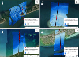
Global ICESat-2 Nearshore Coastal Bathymetry Data Product Earn's Editor Highlight Recognition
jeremy harrell
by jeremy harrell