University of Texas logo with shield on left and 'The University of Texas at Austin Center for Space Research Cockrell School of Engineering' on right
  • About
    • Visit Us
    • News and Events
    • History
    • Affiliations
  • Research
    • Gravity Field
    • Quantum Pathways Institute
    • 3D Geospatial Laboratory
    • Radar Applications
    • McDonald Geodetic Observatory
    • Satellite Geodesy
    • Cis-lunar Exploration
    • Small Satellite Technologies
    • Urban Climate Studies
  • Missions
    • Current Missions
      • SCOPE
      • ICESat-2
      • ABOVE
      • STV
      • GRACE-FO
      • GRACE-C
    • Past Missions
      • GRACE
      • ICESat
  • People
    • CSR Leadership
    • Faculty Affiliates
    • Support Staff
    • Research Staff
  • Education and Outreach
    • Undergraduate and Graduate Research
    • LiftOff Summer Institute
    • SEES
    • Internships
  • Services
    • Open Source Tools
    • VIPER
    • Controlled Unclassified Information
  • Search

UT System and NASA Sign Space Act Agreement to Advance Research, Workforce Development, and STEM Engagement


by Angelica Kruizinga

An illustration of NASA’s Europa Clipper spacecraft.

Space Research at UT: Microbes, Satellites and Deep Space Discoveries

Angelica Kruizinga


by Angelica Kruizinga

Texas Engineer Lori Magruder.

Lori Magruder Elected Associate Fellow of AIAA

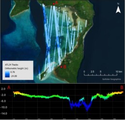
Angelica Kruizinga Lori Magruder, an associate professor in the Department of…


by Angelica Kruizinga

A rendering of the NISAR satellite in space.

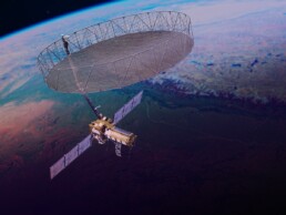
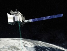
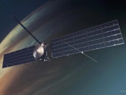
Texas Engineer Joins NISAR Satellite Science Team

Angelica KruizingaA first-of-its-kind satellite just launched into space to map…


by Angelica Kruizinga

ICESat-2 satellite orbiting Earth in space.

Space Laser Tech Maps Mysterious Nearshore Terrain

Angelica Kruizinga


by Angelica Kruizinga

UT Center for Space Research Education and Outreach Department Receives Funding through Texas Space Commission’s Space Exploration and Aeronautics Research Fund (SEARF)

Angelica Kruizinga


by Angelica Kruizinga

This true-color image of Kiriwina Island in in Papua New Guinea shows the 55 tracks of ATL24 bathymetry data (top) and the bathymetric elevation profile of the island's lagoon from Point A to Point B (bottom). Credit: Chris Parrish

NASA, CSR, and Oregon State University Collaborate to Release ICESat-2 Global Bathymetry Data Product

Angelica Kruizinga


by Angelica Kruizinga

Texas Engineer Maruthi Akella.

Maruthi Akella Named Fellow of India’s Department of Science and Technology

Angelica Kruizinga


by Angelica Kruizinga

CSR Co-Hosts National Defense in Space Summit

Angelica KruizingaThe University of Texas Center for Space Research co-hosted…


by Angelica Kruizinga

UTCSR Education and Outreach Department Receives 2024 Stand Up for STEM Award

Angelica Kruizinga


by Angelica Kruizinga

  • 1
  • 2
  • 3