History
50 + years of Involvement in Space Missions
Beacon Explorer C (1965)
The main purpose of Beacon Explorer-C was to record observations of electron content between the earth and the satellite worldwide and carried a passive laser tracking reflector. UT Austin participated in investigations on use of satellite laser ranging for precise orbit determination POD and to study the shape of the Earth through variations in its gravity field. UT Austin provided the initial SLR determination of the Earth’s polar motion
![]()
GEOS 3 (1976)
GEOS-3, or Geodynamics Experimental Ocean Satellite 3 was the third and final satellite as part of NASA’s Geodetic Earth Orbiting Satellite/Geodynamics Experimental Ocean Satellite program (NGSP) to better understand and test satellite tracking systems. As a team member, UT Austin participated to study the initial use of Satellite Laser Ranging and Satellite Altimeter for Precision Orbit and Regional Gravity Model Determination

SeaSat (1978)

Seasat was launched on June 27, 1978 and operated for 105 days. It was one of the earliest Earth-observing satellites which was designed to test various oceanographic sensors to gain better understand of the Earth’s seas. The University of Texas at Austin led the NASA/DOD Precision Orbit Determination and Satellite Altimeter investigation team whose goal was to deliver accurate ocean surface topography for gravity measurements
While short-lived, it set the stage for a series of altimeter satellites to follow. The University of Texas was among the first to process radar altimeter data to determine sea level heights from space. Post launch analysis of the important global data set demonstrated the potential of satellite altimeter data for general oceanographic studies and provided the basis for proposing the TOPEX/Poseidon mission

LAGEOS-1 (1976) and LAGEOS-2 (1992)
LAser GEOdynamic Satellite are a series of two scientific research satellites designed to provide an orbiting laser ranging benchmark for geodynamical studies of the Earth. Each satellite is a high-density passive laser reflector in a very stable medium Earth orbit (MEO). The LAGEOS satellites are covered with 426 cube corner reflectors with all but four of these reflectors made with fused silica glass. The other four reflectors are made of germanium to obtain measurements in the infrared for experimental studies of reflectivity and satellite orientation. They have no on-board sensors or electronics, and are not attitude-controlled.
UT Austin was among the early researchers that demonstrated the ability to measure plate motion using SLR. UT was also the first SLR analysis center to regularly contribute Earth Orientation Parameters to the USNO for combination with other techniques. UT participated in NASA Crustal Dynamics Science Team and provided definitive results for tectonic plate motion and Earth polar motion. UT also provided the determination of first measurements of climate-induced time variable gravity, provided determination of the value for Earth’s mass and GM constant which is still the standard in use. The SLR tracking to these targets has allowed UT Austin to provide a wide variety of geodetic results, which continues to this day.

SPOT-2 (1990 – 2009)
SPOT-2 was an imaging satellite with a completely new radiometric tracking system on board called DORIS developed by the French Space Agency (CNES). UT Austin was among the first to establish a DORIS-based tracking network solution, which prepared us for processing DORIS tracking of the future altimeter satellites TOPEX/Poseidon and Jason-1 and 2.
ERS-1 (1990 – 2000) and ERS-2 (1995 – 2011)
The first European Remote Sensing satellite was intended to be the first test of another new radiometric tracking system from Germany called PRARE. UT Austin, funded by NASA, was the only US organization that participated in the deployment of the ground stations. Unfortunately, the on-board component failed almost immediately due to radiation damage. PRARE was successfully deployed on ERS-2, and UT Austin was the primary US analysis team. The system proved it was capable of precise orbit determination, but the equipment was complicated and did not get wide acceptance in the geodetic community. UT Austin also provided support for precision orbit determination and ocean products verification for the U.S. World Ocean Circulation Experiment (WOCE).

TOPEX/Poseidon (1992 – 2005)
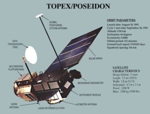
TOPEX/Poseidon was the first in a series of joint CNES/NASA altimeter missions to measure the long-term variations in global sea surface variations, including measuring global sea level rise for the first time. UT Austin worked jointly with NASA/GSFC on the precision orbit determination team with a goal of sub-10 cm radial orbit accuracy. Ultimately, an orbit accuracy of a few cm was achieved. A large part of that success was the development of state-of-the-art global gravity model determination capabilities, an effort that ultimately helped UT Austin to be selected to lead the GRACE mission.

Jason-1 (2001 – 2013) & Jason-2 (2008 – 2019)
Jason-1 and Jason-2 were follow-on CNES/NASA joint altimeter missions launched into an identical orbit as T/P. Following the exact same ground-track allowed the continued monitoring of global sea level rise with sub-mm/year accuracy. UT Austin and CNES jointly led the precision orbit determination team for both missions.

GRAVITY PROBE-B (2004 – 2005)
As a member of the Gravity Probe-B mission’s Science Advisory Committee, UT Austin participated in the Stanford University mission to test two unverified predictions of general relativity: the geodetic effect and frame-dragging.

GRACE (2002)
GRACE is an award-winning mission that has changed the way we study the Earth’s gravitational field and the Earth system. The Gravity Recovery and Climate Experiment (GRACE), a collaboration between US and German space agencies (NASA and DLR) was launched as pair of satellites on March 17, 2002 to study the key changes in the planet’s hydrological systems, oceans, ice sheets and solid Earth. The mission was designed for 5 years but lasted over 15 years providing unprecedented view into the Earth’s system and has helped improve our understanding of the Earth’s Climate. UT Austin is the home institution of the PI of the GRACE mission, Dr. Byron Tapley. UT Austin oversaw the design of the mission, system design, requirements verification, operations and science data system.

ICEsat/GLAS (2003)
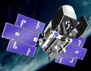
ICESat (Ice, Cloud and land Elevation Satellite) was a NASA satellite mission for measuring ice sheet mass balance, cloud and aerosol heights, as well as land topography and vegetation characteristics. The sole instrument on ICESat was the Geoscience Laser Altimeter System (GLAS), a space-based lidar. Dr. Bob Schutz at UT Austin was the PI of the science instrument, GLAS and the science definition team lead. Precise Orbit Determination (POD) and Precise Attitude Determination (PAD) for the mission was led by the team at UT and was also responsible for the ground validation campaigns. This mission marked the transition from radio to laser altimetry which led to improvement in the precision.

LARES (2012) & LARES-2 (2022)
Along with LAGEOS-1 and 2, LARES and LARES-2 have together been used to validate General Relativity’s prediction of frame dragging in a collaboration between UT Austin, NASA, and the Italian Space Agency (ASI).

GRACE-FO (2018)
The Gravity Recovery and Climate Experiment Follow-On (GRACE-FO) mission is a partnership between NASA and the German Research Centre for Geosciences (GFZ). GRACE-FO is a successor to the original GRACE mission, which orbited Earth from 2002-2017. GRACE-FO continues the work of tracking Earth’s water movement to monitor changes in underground water storage, large lakes and rivers, soil moisture, ice sheets, glaciers and sea level. UT Austin is part of the mission science data system and houses the science operations management tasks for the mission. Prior to the launch, UT Austin also contributed to the system requirements validation and verifications and instrument calibration analysis.

ICEsat-2 (2019)
ICESat-2 (Ice, Cloud and land Elevation Satellite-2) is a second generation of the laser altimeter mission by NASA. The sole instrument on ICESat-2 is the Advanced Topographic Laser Altimeter System (ATLAS), a space-based lidar. The cutting-edge lidar technology aboard ICESat-2 is optimized for the polar regions, where observations help researchers evaluate the current state of our ice sheets and sea ice. The satellite’s global coverage also delivers high-resolution measurements of tree heights, inland water reservoirs, cloud characteristics, and oceans, improving our knowledge of biomass estimates, water storage, atmospheric heat flux, and sea level. Since ICESat-2’s launch, data not only have met expectations but also provide a window into other potentially transformational science discoveries.
The efforts in research and development associated with ICESat-2 at UT Austin support a broad range of technical applications and analysis. The team has been involved since 2014 in the mission concept development and implementation studies. We have worked on the airborne simulator for ICESat-2 and designed critical validation strategies to ensure the data quality once on-orbit.

GRACE-C (planned 2028)
GRACE-C (GRACE-Continuity) mission is planned as a collaboration between US and German space agencies (NASA and DLR) for launch in December 2028. GRACE-C will continue the legacy of two highly successful missions and extend the mass change data record into the third decade. UT Austin’s role in the mission is similar to its role in the GRACE-FO mission.